
Big Sur is located along Scenic Highway One approximately 150 miles south of San Francisco and 300 miles north of Los Angeles. Historically, the name Big Sur, was derived from that unexplored and unmapped wilderness area called El Sur Grande which lies along the coast south of Monterey. Today, Big Sur refers to that 90-mile stretch of rugged and awesomely beautiful coastline between Carmel to the north and San Simeon (Hearst Castle) to the south. Highway One winds along its length and is flanked on one side by the majestic Santa Lucia Mountains and on the other by the rocky Pacific Coast.
The scenic qualities and the natural grandeur of the coast which result from the imposing geography, the rich vegetative compositions, and the dramatic meetings of land and sea are the area's greatest single attraction to the public. Big Sur has attained a worldwide reputation for its spectacular beauty. Hiking, backpacking and scenic driving are major recreational activities. Drive carefully. Highway One is one of the best-maintained roads in the world, but its sharp curves and steep hills still preclude high speed driving. This breathtaking stretch of coastline has something to offer any visitor.
History of the Land
Although there were two Mexican land grants awarded in the 1830's, which included most of the area north of the Big Sur Valley, neither grantee settled on the land. It was little more than a century ago when the first permanent settlers arrived in Big Sur.
At the turn of the century Big Sur sustained a larger population than it does today. A vigorous redwood lumbering industry provided livelihoods for many. The Old Coast Trail, which had been the only link between homesteads, was still little more than a wagon trail. Steamers transported heavy goods and supplies and harbored at Notley's Landing, Partington Cove, and the mouth of the Little Sur River. Navigation was treacherous, and in 1889, the Point Sur Lighthouse Station began sending its powerful beam to protect ships from the hazards of the coastline.
In 1937, the present highway was completed after eighteen years of construction at a considerable expense even with the aid of convict labor. The highway has since been declared California's first Scenic Highway, and it provides a driving experience unsurpassed in natural beauty and scenic variety. Electricity did not arrive in Big Sur until the early 1950's, and it still does not extend the length of the coast or into the more remote mountainous areas.
McWay Falls, Julia Pfeiffer Burns State Park
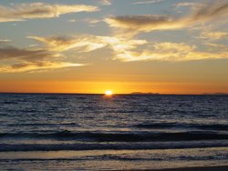
Beaches ...hard to find, but worth the effort
While Big Sur's beaches hardly resemble the vast stretches of sun-baked sand that dot Southern California's easily accessible coastline; they offer the visitor a wide variety of recreational possibilities. Even during the summer, Big Sur's beaches are subject to generally cool weather. Sunny days are sporadic as a blanket of seasonal fog often hugs the coastline, dropping the temperature in the process. To be prepared, bring a change of warm clothes. Also, bring a pair of sturdy shoes. Big Sur's beaches require at least a short hike.
Private property and Big Sur's steep terrain makes most of its coastline inaccessible to the public. Fortunately for the visitor, however, several State Park and U.S. Forest Service beaches are open to the public all year. The following beaches are recommended due to easy access and breath-taking scenery:
PFEIFFER BIG SUR STATE PARK - This is the most popular state park in Big Sur. Visitors can enjoy many scenic loop hikes. Stop at the overlooks for spectacular views of the Pacific Ocean and Big Sur Gorge. The 810 acres of the park are full of trees such as redwoods, willows and oak. Wildlife, like boars, raccoons and birds make the park home. There are 218 camping sites. And Big Sur Lodge offers indiviual rooms and cabin accommodations. Pfeiffer Big Sur State Park is located 26 miles south of Carmel on Highway One.
ANDREW MOLERA STATE PARK - Located 23 miles south of Carmel, Andrew State Park is the largest state park on the Big Sur Coast. A wide, scenic, mile-long path leads to a sandy beach that is sheltered from the wind by a large bluff to the north. The path itself is as much a delight as the beach, taking you through a meadow filled with wildflowers and sycamore trees, offering fine views of the coastal mountain range to the east. The path parallels the Big Sur River, which enters the sea adjacent to Molera's beach.
PFEIFFER BEACH - Big Sur's most popular coastal access point, Pfeiffer Beach is hard to find if you've never been to it before. From a large parking area at the end of the road, a short, well-marked path leads to the beach. Cliffs tower above this breathtaking stretch of sand, and a large arch-shaped rock formation just offshore makes for some dazzling sunsets.
JULIA PFEIFFER BURNS STATE PARK - Julia Pfeiffer Burns State Park stretches from the Big Sur coastline into nearby 3,000-foot ridges. The park features redwood, tan oak, madrone, chaparral, and an 80-foot waterfall that drops from granite cliffs into the ocean from the Overlook Trail. A panoramic view of the ocean and miles of rugged coastline is available from the higher elevations along the trails east of Highway 1.
Big Sur River
SAND DOLLAR BEACH - Just a mile south of the U.S. Forest Service Station in Pacific Valley and 14 miles north of the San Luis Obispo County line lies Sand Dollar Beach. From a large parking lot across the Highway One from Plaskett Creek Campground, a well-built stairway leads to a crescent-shaped beach that's protected from the wind by bluffs. Sand Dollar offers visitors the widest expanse of sand along the Big Sur Coast, and possibly the mildest weather. Standing on the beach and looking northeast, towering 5,155-foot Cone Peak is visible. For an interesting side trip, visit Jade Cove, which is located two miles south of Sand Dollar Beach. Big Sur's south coast is famous for its jade reserves, and Jade Cove is a popular spot for beachcombers and rockhounds.
Other points of public coastal access in Big Sur include Garrapata State Beach, Partington Cove, Mill Creek and Willow Creek.
Seasons and Accommodations
Big Sur is beautiful and mild all year around. January generally has good weather but it does begin the rainy season. In the winter Big Sur is blessed with the annual Gray Whale migration. At this time the whole population of Grey Whales migrates from Alaska to breed and have babies inthe warm lagoons of Mexico, returning along the same coastal route beginning in February and March. Whales are very visible from the roadside turnouts. February is the quietest month when you would have the beaches and the forest to yourself.
By spring, the hills become alive with California poppies and wildflowers and the streams run clear and deep. The creeks flow with color from calla lilies and willows.
July and August are the best for hiking, nature walks or campfire programs in the state parks.
The Summer months are for family activities; tubing down the Big Sur River, exploring tide pools along the Big Sur beaches, having a barbecue in one of Big Sur's beautiful State Parks. Summer brings us the largest mammals on earth, the Blue Whales. In addition, the Humpback Whales and the Orcas are in town. Enjoy these amazing giants from the roadside turnouts.
Fifteen Hotels, Inns and Lodgings are available in the area. Rooms can either be in Cabins at one of the campgrounds, rooms at a monastery, resorts or even an institute that features retreats and workshops. There are eleven campgrounds, some with cabin facilities and others with shower and laundry facilities. Camping is available in Andrew Molera State Park and Pfeiffer-Big Sur State Park.
The scenic qualities and the natural grandeur of the coast which result from the imposing geography, the rich vegetative compositions, and the dramatic meetings of land and sea are the area's greatest single attraction to the public. Big Sur has attained a worldwide reputation for its spectacular beauty. Hiking, backpacking and scenic driving are major recreational activities. Drive carefully. Highway One is one of the best-maintained roads in the world, but its sharp curves and steep hills still preclude high speed driving. This breathtaking stretch of coastline has something to offer any visitor.
History of the Land
Although there were two Mexican land grants awarded in the 1830's, which included most of the area north of the Big Sur Valley, neither grantee settled on the land. It was little more than a century ago when the first permanent settlers arrived in Big Sur.
At the turn of the century Big Sur sustained a larger population than it does today. A vigorous redwood lumbering industry provided livelihoods for many. The Old Coast Trail, which had been the only link between homesteads, was still little more than a wagon trail. Steamers transported heavy goods and supplies and harbored at Notley's Landing, Partington Cove, and the mouth of the Little Sur River. Navigation was treacherous, and in 1889, the Point Sur Lighthouse Station began sending its powerful beam to protect ships from the hazards of the coastline.

In 1937, the present highway was completed after eighteen years of construction at a considerable expense even with the aid of convict labor. The highway has since been declared California's first Scenic Highway, and it provides a driving experience unsurpassed in natural beauty and scenic variety. Electricity did not arrive in Big Sur until the early 1950's, and it still does not extend the length of the coast or into the more remote mountainous areas.
McWay Falls, Julia Pfeiffer Burns State Park
Beaches ...hard to find, but worth the effort
While Big Sur's beaches hardly resemble the vast stretches of sun-baked sand that dot Southern California's easily accessible coastline; they offer the visitor a wide variety of recreational possibilities. Even during the summer, Big Sur's beaches are subject to generally cool weather. Sunny days are sporadic as a blanket of seasonal fog often hugs the coastline, dropping the temperature in the process. To be prepared, bring a change of warm clothes. Also, bring a pair of sturdy shoes. Big Sur's beaches require at least a short hike.
Private property and Big Sur's steep terrain makes most of its coastline inaccessible to the public. Fortunately for the visitor, however, several State Park and U.S. Forest Service beaches are open to the public all year. The following beaches are recommended due to easy access and breath-taking scenery:
PFEIFFER BIG SUR STATE PARK - This is the most popular state park in Big Sur. Visitors can enjoy many scenic loop hikes. Stop at the overlooks for spectacular views of the Pacific Ocean and Big Sur Gorge. The 810 acres of the park are full of trees such as redwoods, willows and oak. Wildlife, like boars, raccoons and birds make the park home. There are 218 camping sites. And Big Sur Lodge offers indiviual rooms and cabin accommodations. Pfeiffer Big Sur State Park is located 26 miles south of Carmel on Highway One.
ANDREW MOLERA STATE PARK - Located 23 miles south of Carmel, Andrew State Park is the largest state park on the Big Sur Coast. A wide, scenic, mile-long path leads to a sandy beach that is sheltered from the wind by a large bluff to the north. The path itself is as much a delight as the beach, taking you through a meadow filled with wildflowers and sycamore trees, offering fine views of the coastal mountain range to the east. The path parallels the Big Sur River, which enters the sea adjacent to Molera's beach.
PFEIFFER BEACH - Big Sur's most popular coastal access point, Pfeiffer Beach is hard to find if you've never been to it before. From a large parking area at the end of the road, a short, well-marked path leads to the beach. Cliffs tower above this breathtaking stretch of sand, and a large arch-shaped rock formation just offshore makes for some dazzling sunsets.
JULIA PFEIFFER BURNS STATE PARK - Julia Pfeiffer Burns State Park stretches from the Big Sur coastline into nearby 3,000-foot ridges. The park features redwood, tan oak, madrone, chaparral, and an 80-foot waterfall that drops from granite cliffs into the ocean from the Overlook Trail. A panoramic view of the ocean and miles of rugged coastline is available from the higher elevations along the trails east of Highway 1.
Big Sur River
SAND DOLLAR BEACH - Just a mile south of the U.S. Forest Service Station in Pacific Valley and 14 miles north of the San Luis Obispo County line lies Sand Dollar Beach. From a large parking lot across the Highway One from Plaskett Creek Campground, a well-built stairway leads to a crescent-shaped beach that's protected from the wind by bluffs. Sand Dollar offers visitors the widest expanse of sand along the Big Sur Coast, and possibly the mildest weather. Standing on the beach and looking northeast, towering 5,155-foot Cone Peak is visible. For an interesting side trip, visit Jade Cove, which is located two miles south of Sand Dollar Beach. Big Sur's south coast is famous for its jade reserves, and Jade Cove is a popular spot for beachcombers and rockhounds.
Other points of public coastal access in Big Sur include Garrapata State Beach, Partington Cove, Mill Creek and Willow Creek.
Seasons and Accommodations
Big Sur is beautiful and mild all year around. January generally has good weather but it does begin the rainy season. In the winter Big Sur is blessed with the annual Gray Whale migration. At this time the whole population of Grey Whales migrates from Alaska to breed and have babies inthe warm lagoons of Mexico, returning along the same coastal route beginning in February and March. Whales are very visible from the roadside turnouts. February is the quietest month when you would have the beaches and the forest to yourself.
By spring, the hills become alive with California poppies and wildflowers and the streams run clear and deep. The creeks flow with color from calla lilies and willows.
July and August are the best for hiking, nature walks or campfire programs in the state parks.
The Summer months are for family activities; tubing down the Big Sur River, exploring tide pools along the Big Sur beaches, having a barbecue in one of Big Sur's beautiful State Parks. Summer brings us the largest mammals on earth, the Blue Whales. In addition, the Humpback Whales and the Orcas are in town. Enjoy these amazing giants from the roadside turnouts.
Fifteen Hotels, Inns and Lodgings are available in the area. Rooms can either be in Cabins at one of the campgrounds, rooms at a monastery, resorts or even an institute that features retreats and workshops. There are eleven campgrounds, some with cabin facilities and others with shower and laundry facilities. Camping is available in Andrew Molera State Park and Pfeiffer-Big Sur State Park.


No hay comentarios:
Publicar un comentario